Explore The British Isles

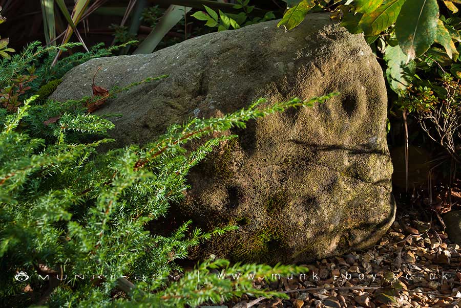
Rivington Cup Marked Stone
The only prehistoric rock art recognised as being authentic in the Rivington area, was found at an undisclosed location near the banks of the Lower Rivington Reservoir. The carved stone fragment is in the form of a small boulder, smoothed and worn in a similar manner to many of the boulders found around the reservoirs or in stream beds and was probably used in the construction of the reservoir, the significant markings unnoticed.
The visible portion of the design of the artwork on the stone features the familiar “Cup and Ring” markings that are fairly simple, with only a single expample of a ring mark – although we are seeing only a fragment of the full design. However, the number and proximity of the many cup marks is notable and perhaps less commonly for this type of artefact, the cup marks themselves seem to have been used to form a larger pattern of which a section of arc is clearly visible today.
The Rivington Cup Marked Stone is located in the Anderton Centre as part of a forlorn display of a few shrubs and a couple of other non-descript boulders of the local stone, surrounded by garden ornament type gravel. One can imagine that when it was completed the display was a bland and unimaginitive “corporate” style car park ornament, today it is seemingly forgotten. There are no signs or information regarding this important and unique example of local prehistoric art on site and interested parties are required to trespass in order to see it locked away in a car park.
This artefact should be moved to a public place, to be viewed by anyone. It is our ancestral heritage.
Local History
Historic monuments near Rivington Cup Marked Stone
- Headless Cross, Grimeford – 0.81 km away
- Bretters Farm moated site and two fishponds – 2.76 km away
- Pike Stones chambered long cairn – 3.48 km away
- Round cairn on Winter Hill – 3.61 km away
- Round cairn on Noon Hill – 2.79 km away
- Round Loaf bowl barrow on Anglezarke Moor – 4.69 km away
- The Moat House moated site 600m WNW of St David’s Church – 5.12 km away
- Cross base on Standish Wood Lane 700m south east of Standish Hall – 7.72 km away
- Moated site at Arley Hall, Haigh near Wigan – 4.51 km away
- Mabs Cross on Standishgate, 20m west of Mabs Cross School building – 8.33 km away
- Gidlow Hall moated site, Aspull, 560m NNE of Pennington Hall – 6.74 km away
- Cross base at the junction of Standish Green Lane, Standish Wood Lane and Beech Walk, 200m NNW of Strickland House Farm, Standish – 7.33 km away
- Cross base on Green Lane 300m north of Strickland House Farm, Standish – 7.19 km away
- Market cross in the marketplace to the west of St Wilfrid’s Church, Standish – 6.86 km away
- Round cairn 280m west of Old Harpers Farm – 4.35 km away
- Haigh Sough mine drainage portal, 310m west of Park House – 7.29 km away